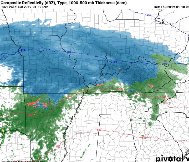
|
|
Post by Frivolousz21 on Jan 10, 2019 0:45:35 GMT -6
There is a rule of thumb that I've used personally at times that has helped me some when dealing with bigger snows. Take the max value in the models...and slash 20% of the top...for no other reason than because the number of times model over-forecast snow vs. under-forecast snow is pretty high. The 20% deduction is just a good sanity check. In this case...lets say the top QPF is on average 1.0" then 8.0" of snow is pretty reasonable. So that's where I sit with the high end of my forecast...I'm very happy with where I sit with my forecast right now...widespread 4-8" ... some sleet/mixing concerns south..but not enough to drop them out of the 4-8 range. There is definitely potential for upwards of 10"... maybe a little more...but at this stage of the game...I see little benefit to pushing the numbers up any...and then risk having to drop them back down again. I'd rather hold with 4-8...and continue "steady as she goes" and wait until the storm is onshore and we get inside 24 hours. 4-8 is a beefy storm for us...and gets the public ready for the potential impact. There is nothing worse in my opinion than to watch a forecast yo-yo. 2-3, then 3-6, then 4-8, the 3-6, then 2-4...and we get 5. We have all seen that happen many times in the past. If it ain't broken...don't fix it. 4-8 is not broken. Also, this is not a wind event...and it is a weekend...so the impact is not going to be what you would see if this happened during the week. I have a rule of thumb. Don't listen to the guy who is going to be smoking Cirrus in Cincinnati. We'll live stream the snow plows abandoned after being stuck in 20' drifts. I'm just kidding of course. About the smoking cirrus. I'm sure Cincy can muster a heavy coating. |
|
|
|
Post by Snowman99 on Jan 10, 2019 0:46:29 GMT -6
|
|
|
|
Post by jmg378s on Jan 10, 2019 0:46:40 GMT -6
I think Chris preferred we not post Euro products like QPF due to the whole license issue. |
|
|
|
Post by Snowman99 on Jan 10, 2019 1:00:36 GMT -6
I have profound confidence in saying it will not snow around here later this week. Hmm. Maybe I should say this more often. |
|
|
|
Post by unclesam6 on Jan 10, 2019 1:12:07 GMT -6
Have we hit slam dunk status yet
|
|
|
|
Post by Snowman99 on Jan 10, 2019 1:13:42 GMT -6
Have we hit slam dunk status yet Is it 6 hours after the storm?  |
|
|
|
Post by Snowstorm920 on Jan 10, 2019 1:32:41 GMT -6
So the EPS is just ridiculous. The mean snowfall for the metro is like 10-11" Yes the mean
Either the euro camp is smoking some strong stuff or we are about to get blasted with one of the biggest storms we've seen around here in a long time
|
|
|
|
Post by Snowman99 on Jan 10, 2019 1:33:51 GMT -6
Soooooooooo..the euro ensembles are just mind boggling, lol. The entire metro is 10"+, slightly less in IL. Bullseye of 11 covering all of Franklin, Gasconade and Jefferson Counties. And parts of St. Louis, Warren, St Charles, Washington and Crawford counties. I don't think Union could be any closer to the center if it tried. Ha.
|
|
|
|
Post by Snowman99 on Jan 10, 2019 1:34:14 GMT -6
Ahh..ya beat me to it 920
|
|
|
|
Post by Snowman99 on Jan 10, 2019 1:37:02 GMT -6
Every single model has over an inch qpf, except the GFS.
The Ukmet, euro and FV3 have had a big one for the longest time..fv3 maybe THE longest.
|
|
|
|
Post by Snowstorm920 on Jan 10, 2019 1:38:05 GMT -6
EPS also sticking with a 90 to 99% chance of 6" or more of snow for the metro
I kid you not there's also a 40% chance of 12" of snow or more just west of STL
|
|
|
|
Post by Snowman99 on Jan 10, 2019 1:40:51 GMT -6
96-98% chances of 6 or more inches.99.9% in Jeffco.
25-35% chances of over a foot. Union being in the 35.
Something is going to F*** this up.
|
|
|
|
Post by Snowman99 on Jan 10, 2019 1:42:31 GMT -6
I have never seen numbers like this...outside of the yearly historical northeast blizzards.
|
|
|
|
Post by Snowstorm920 on Jan 10, 2019 1:50:10 GMT -6
96-98% chances of 6 or more inches.99.9% in Jeffco. 25-35% chances of over a foot. Union being in the 35. Something is going to F*** this up. Where do you find these more specific numbers? |
|
|
|
Post by Snowman99 on Jan 10, 2019 1:57:15 GMT -6
Missouri view of the eps on weathermodels.com..
|
|
|
|
Post by Snowman99 on Jan 10, 2019 1:57:42 GMT -6
Plumes are up to a mean of 6 for Lambert
|
|
|
|
Post by cardsnweather on Jan 10, 2019 2:14:17 GMT -6
Plumes are up to a mean of 6 for Lambert They are always low in the beginning. I usually don’t really take them into consideration until we are inside 48 if not 36. I imagine 09z will have several members over a Foot and the mean at 9-10 NAM rolling. |
|
|
|
Post by cardsnweather on Jan 10, 2019 2:18:43 GMT -6
Nam may be historic.
How nice is it to have models consistently trending stronger each run instead of what usually happens here?
|
|
|
|
Post by Snowman99 on Jan 10, 2019 2:19:39 GMT -6
|
|
|
|
Post by Snowman99 on Jan 10, 2019 2:27:58 GMT -6
nam is going to be pretty unreal
|
|
|
|
Post by cardsnweather on Jan 10, 2019 2:29:39 GMT -6
nam is going to be pretty unreal It’s going to be a run you save in your files forever. Someone is going to be approaching 20” here. |
|
|
|
Post by guyatacomputer - NE St. Peters on Jan 10, 2019 2:34:26 GMT -6
There is a rule of thumb that I've used personally at times that has helped me some when dealing with bigger snows. Take the max value in the models...and slash 20% of the top...for no other reason than because the number of times model over-forecast snow vs. under-forecast snow is pretty high. The 20% deduction is just a good sanity check. In this case...lets say the top QPF is on average 1.0" then 8.0" of snow is pretty reasonable. So that's where I sit with the high end of my forecast...I'm very happy with where I sit with my forecast right now...widespread 4-8" ... some sleet/mixing concerns south..but not enough to drop them out of the 4-8 range. There is definitely potential for upwards of 10"... maybe a little more...but at this stage of the game...I see little benefit to pushing the numbers up any...and then risk having to drop them back down again. I'd rather hold with 4-8...and continue "steady as she goes" and wait until the storm is onshore and we get inside 24 hours. 4-8 is a beefy storm for us...and gets the public ready for the potential impact. There is nothing worse in my opinion than to watch a forecast yo-yo. 2-3, then 3-6, then 4-8, the 3-6, then 2-4...and we get 5. We have all seen that happen many times in the past. If it ain't broken...don't fix it. 4-8 is not broken. Also, this is not a wind event...and it is a weekend...so the impact is not going to be what you would see if this happened during the week. Once you get to the 6-8 inch level things are pretty much at max disruption of routine activities already. Yeah, it's an important difference for snow removal and emergency preparedness, or for a nursing home that needs to be concerned about the staffing. But for the average person once things get to that point school, church and social activities will all be cancelled, the stores will be closed and people will pretty much stay where they're at. Having said all that this may be one of those rare occasions where the milk, bread, egg and toilet paper panic runs to the grocery stores Thursday and Friday would be warranted. |
|
|
|
Post by cardsnweather on Jan 10, 2019 2:34:43 GMT -6
Hi-res at Hr 45 is absolutely beautiful
|
|
|
|
Post by cardsnweather on Jan 10, 2019 2:37:26 GMT -6
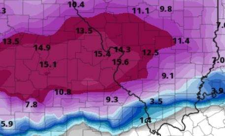
Wait until you guys see this 06z NaM snowfall map!!
|
|
|
|
Post by Snowstorm920 on Jan 10, 2019 2:38:18 GMT -6
Ya the NAM is ridiculous
Another model run another foot plus for the metro
|
|
|
|
Post by Snowman99 on Jan 10, 2019 2:40:20 GMT -6
Has 1.2-1.4 qpf over the whole metro pretty much. Not too different from the euro. The NAM is usually to high in qpf...but you gotta say wtf? Because its in line with about every other model, except the GFS.
|
|
|
|
Post by Sparkman - Wildwood, Mo on Jan 10, 2019 2:40:31 GMT -6
This is nuts.
|
|
|
|
Post by cardsnweather on Jan 10, 2019 2:41:31 GMT -6
 Hires 06z  06z nam snowfall map |
|
|
|
Post by guyatacomputer - NE St. Peters on Jan 10, 2019 2:42:24 GMT -6
Can we start calling it things like snowmaggedeon or snowpocalypse? Though it's not the same as when the NYC media pounds us over the head with it as we get bupkiss
|
|
|
|
Post by Snowstorm920 on Jan 10, 2019 2:44:56 GMT -6
Just because it’s to crazy not to post  |
|