|
|
Post by bororug on Jan 19, 2019 13:26:34 GMT -6
That band from Farmington through Ste. Gen into Illinois looks dang good.
|
|
|
|
Post by RyanD on Jan 19, 2019 13:27:08 GMT -6
Wow! Really coming down. Wish this would last longer. I bet it is a whiteout in Red Bud.
|
|
|
|
Post by showtime - Marissa on Jan 19, 2019 13:28:40 GMT -6
I’m guessing between 1/4 and a 1/2 inch so far.... wind is blowing everything around
|
|
|
|
Post by toddatfarmington on Jan 19, 2019 13:28:57 GMT -6
|
|
|
|
Post by dragons7stegen on Jan 19, 2019 13:29:45 GMT -6
That band from Farmington through Ste. Gen into Illinois looks dang good. It's pouring snow. Visibility down to close 1/4 mile. Windy and accumulating fast. |
|
|
|
Post by maddogchief on Jan 19, 2019 13:32:10 GMT -6
Which storm is the Tuesday storm? The one over Idaho, or northern CA?
|
|
|
|
Post by weatherj on Jan 19, 2019 13:33:41 GMT -6
Snowing here now, the radar is looking good over here for a few hours.
|
|
|
|
Post by STGOutdoors on Jan 19, 2019 13:34:30 GMT -6
Man it's rippin. This is as close to a true blizzard as I've ever seen. Right there next to Jan 5, 2014. Amount obviously won't come close but it's awesome right now.
I don't intend to rub it in, but I'm gonna keep reporting while the getting is good lol.
|
|
|
|
Post by STGOutdoors on Jan 19, 2019 13:35:48 GMT -6
Hope to hang onto it for a few more hours but I know that back edge will come quicker than I want it to.
|
|
|
|
Post by Snowstorm920 on Jan 19, 2019 13:37:14 GMT -6
Man it's rippin. This is as close to a true blizzard as I've ever seen. Right there next to Jan 5, 2014. Amount obviously won't come close but it's awesome right now. I don't intend to rub it in, but I'm gonna keep reporting while the getting is good lol. You guys deserve it. You got kinda screwed down there while we got a foot last weekend. Don’t be afraid to post some pics to rub it in |
|
|
|
Post by RyanD on Jan 19, 2019 13:39:09 GMT -6
The southerners definitely deserve it. I know I won't get much up here but at this point I'm happy with anything.
|
|
|
|
Post by Kathy Walker - Fredericktown on Jan 19, 2019 13:40:16 GMT -6
I’m just south of Farmington, between Farmington and Fredericktown. Heavy snow and blowing conditions. Yard covered. Looks amazing! I don’t feel bad at all for STL. I can’t count the number of times I sat here and read the forum just to hear what it was like to get snow while I had a dusting to nothing. We’re not even close to catching up. We deserve some love too. :-) Amen! And with our luck down here, this storm may be it for the year. |
|
|
|
Post by jmg378s on Jan 19, 2019 13:42:26 GMT -6
I went back through the mesoanalysis and here's the evolution of the 850mb low. You can see the original decaying low in northern MO. Then a developing wave axis, very approximately drawn. And finally a new center of circulation in AR. Not well modeled and makes for a tricky forecast. Leaves us in the metro dry. But I am happy members in the southern part of the area are getting in on some fun weather.  |
|
|
|
Post by Frivolousz21 on Jan 19, 2019 13:43:30 GMT -6
The dry air monster is really undercutting the snow this far back.
Looks like we will end up with a half inch. It's impossible to tell but the world is white again
|
|
|
|
Post by dragons7stegen on Jan 19, 2019 13:44:34 GMT -6
Hope to hang onto it for a few more hours but I know that back edge will come quicker than I want it to. Agreed. Huge flake size now. Hope to post some pictures I took in a little bit. Huge freaking flakes as big as I have seen in a long time! |
|
|
|
Post by Frivolousz21 on Jan 19, 2019 13:46:15 GMT -6
I went back through the mesoanalysis and here's the evolution of the 850mb low. You can see the original decaying low in northern MO. Then a developing wave axis, very approximately drawn. And finally a new center of circulation in AR. Not well modeled and makes for a tricky forecast. Leaves us in the metro dry. But I am happy members in the southern part of the area are getting in on some fun weather. It's crazy how close we were to a 6-12" up i44 storm |
|
|
|
Post by RyanD on Jan 19, 2019 13:47:02 GMT -6
That deathband from Farmington to Red Bud looks amazing. It is still snowing nicely on the NE side of Waterloo but won't last much longer. Don't think I'll pick up more than a half inch. At least everything is white again.
|
|
|
|
Post by dschreib on Jan 19, 2019 13:47:10 GMT -6
Hope to hang onto it for a few more hours but I know that back edge will come quicker than I want it to. Agreed. Huge flake size now. Hope to post some pictures I took in a little bit. Huge freaking flakes as big as I have seen in a long time! That's the difference between yours and ours right now. Pouring salt shaker and pencil erasers in Marissa. |
|
|
|
Post by Snowstorm920 on Jan 19, 2019 13:48:51 GMT -6
The dry air monster is really undercutting the snow this far back. Looks like we will end up with a half inch. It's impossible to tell but the world is white again This back edge band over me right now is pretty legit
Moderate snow with blowing snow
|
|
|
|
Post by weatherj on Jan 19, 2019 13:50:11 GMT -6
It's really picking up now, looks like a mini blizzard.
|
|
|
|
Post by showtime - Marissa on Jan 19, 2019 13:51:21 GMT -6
Agreed. Huge flake size now. Hope to post some pictures I took in a little bit. Huge freaking flakes as big as I have seen in a long time! That's the difference between yours and ours right now. Pouring salt shaker and pencil erasers in Marissa. In the last few minutes it started pouring flakes....size has increased also |
|
|
|
Post by WEAXWATCHER on Jan 19, 2019 13:53:04 GMT -6
Picked up pretty significantly here in the north side of Mascoutah... nice dusting on all surfaces. Moderate to heavy snow.
|
|
|
|
Post by cardsnweather on Jan 19, 2019 13:53:24 GMT -6
Nam has far southern Illinois getting a FOOT+
|
|
|
|
Post by cozpregon on Jan 19, 2019 13:53:45 GMT -6
Snowing nicely near Grant's Farm. Roofs are white... ground dusting over.
|
|
|
|
Post by pbc12871 on Jan 19, 2019 13:55:13 GMT -6
Nothing.
|
|
|
|
Post by BRTNWXMAN on Jan 19, 2019 13:56:03 GMT -6
I went back through the mesoanalysis and here's the evolution of the 850mb low. You can see the original decaying low in northern MO. Then a developing wave axis, very approximately drawn. And finally a new center of circulation in AR. Not well modeled and makes for a tricky forecast. Leaves us in the metro dry. But I am happy members in the southern part of the area are getting in on some fun weather. That was definitely not modeled well...I guess the GYB was sorta right after all at least with the h85 track. That transfer of energy definitely left us high and dry up here...and models did pick up on that but were off with the h85 low track for sure. |
|
|
|
Post by perryville on Jan 19, 2019 13:59:52 GMT -6
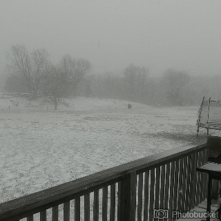
Picture doesn’t do it justice. Blizzard like conditions at times here in western Perry County  |
|
|
|
Post by Frivolousz21 on Jan 19, 2019 14:00:00 GMT -6
TWO THINGS:
1. THERE WILL BE WIDESPREAD COTTON BALL LIGHTS NO LATER ON THIS AFTERNOON THROUGH MOST OF THE EVENING BECAUSE OF THE INTENSE LOW-LEVEL COLD AIR
2. THIS STORM HAS TRENDED SO MUCH WARMER ON THE NORTHEAST COAST THAT MANY OF THE POMPOUS WEATHER WEENIES OUT THERE ARE GOING TO SEE HARDLY ANY SNOW AND IT'S STRAIGHT CHANGE OVER TO RAIN.
SOME OF THEM THAT WERE EXPECTING 8 TO 16 IN AS OF LAST NIGHT OR GOING TO SEE 2-3IN AND THEN RAIN.
SO JOYOUS
|
|
|
|
Post by dschreib on Jan 19, 2019 14:01:37 GMT -6
Let's try this way...
Well...that's annoying. Apologies.
|
|
|
|
Post by Snowstorm920 on Jan 19, 2019 14:02:42 GMT -6
I agree Friv. Hi Res NAM soundings have the snow squall look to them later this evening  |
|