|
|
Post by Worldserieschampions (Chicago) on Jan 23, 2019 22:30:46 GMT -6
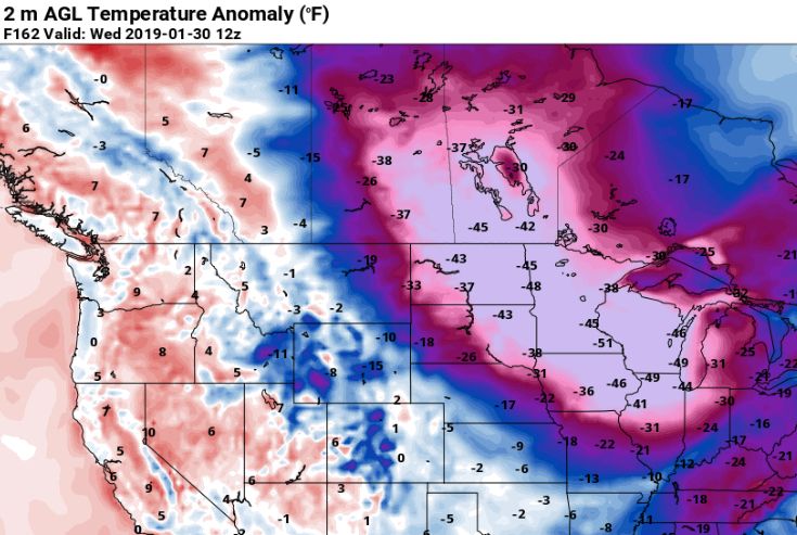 Temp anomaly for next Wednesday. Are these the lows or wind chills? Neither... It's the temperature departure from normal (or average, terminology remains elusive for me). If a typical January day is 30 degrees and the model predicts a temperature of 0 degrees, then that graphic will show -30 degrees representing the predicted difference. |
|
|
|
Post by bellevillewxguy on Jan 23, 2019 22:46:07 GMT -6
Icon continues to be seriously scary with the cold a week from now. Should I wear a coat for the walk to work? Maybe a space heater... I'd grab the space suit.  |
|
|
|
Post by Snowstorm920 on Jan 23, 2019 22:52:29 GMT -6
There's still many opportunities for snow showing up on the models over the next week. The only caveat is they are embedded in the NW flow which makes them unpredictable and difficult for the model to simulate accurately
|
|
|
|
Post by Worldserieschampions (Chicago) on Jan 23, 2019 22:55:25 GMT -6
There's still many opportunities for snow showing up on the models over the next week. The only caveat is they are embedded in the NW flow which makes them unpredictable and difficult for the model to simulate accurately Icon, gfs, and gem all show a clipper Sunday out front the hybrid system. That could lay down a couple inches. Would be kind of annoying if it melted as the other system swings to the north though. |
|
|
|
Post by Snowman99 on Jan 24, 2019 3:33:52 GMT -6
forecast and models are meh. I don't see any snow around here worth while before the arctic air shows up next week. And the models just don't plunge the arctic air ..it kind of stops around here. Have temps 40-50 below normal maybe in IA while maybe 20 below normal around here. Cold, but certainly nothing out of the ordinary or historic by any stretch of the imagination. And with no snow on the ground that is very likely not going to happen. Then all models warm it up after the arctic air. So Feb will start off much warmer after the first couple days.
|
|
|
|
Post by Chris Higgins on Jan 24, 2019 6:29:06 GMT -6
I'm trying not to get to specific on the Clipper times and intensity for this weekend...it just looks too iffy. So going with a very general "Flurries or light snow at times" from late Friday through Sunday. The timing of these things keeps changing...so do the tracks...and it just doesn't make any sense to try and pin anything down at this point.
|
|
|
|
Post by landscaper on Jan 24, 2019 6:39:43 GMT -6
Hopefully we get lucky and catch a clipper, I agree with Snowman, the models are definitely not exciting, the Euro has almost 10 days of below freezing with about an inch of snow. It has .50”-.80” qpf for the metro area I’m assuming that’s in the two warm up days of rain .
|
|
|
|
Post by Chris Higgins on Jan 24, 2019 6:57:04 GMT -6
Hopefully we get lucky and catch a clipper, I agree with Snowman, the models are definitely not exciting, the Euro has almost 10 days of below freezing with about an inch of snow. It has .50”-.80” qpf for the metro area I’m assuming that’s in the two warm up days of rain . That is not a huge suprise. It is the problem when the PV comes too far south. it really supresses the storm track. I suspect that we may get a good storm as the pattern relaxes. It seems we often get a good storm before warming up. |
|
|
|
Post by cardsnweather on Jan 24, 2019 7:19:50 GMT -6
I am ready for one of those 65 degree February days we always get...
|
|
|
|
Post by Tilawn on Jan 24, 2019 7:22:51 GMT -6
It’s frosty enough that it looks like it snowed last night......is that any consolation??
|
|
|
|
Post by STGOutdoors on Jan 24, 2019 7:27:54 GMT -6
Almost hate to say it but the other "S" word came into my mind last night. I love the snow that we've had but when it gets into the teens and single digits and dry I'm starting to think about warmer weather and all the things that come with it. We've had some fun this winter so I'm good.
|
|
|
|
Post by Snowman99 on Jan 24, 2019 7:48:24 GMT -6
Had a lot of standing water in our yard from thw ton of rain on partially frozen ground. Now we have large icy areas. It's a hazard. Lol. Better then mud though.
|
|
|
|
Post by Tilawn on Jan 24, 2019 8:04:04 GMT -6
Had a lot of standing water in our yard from thw ton of rain on partially frozen ground. Now we have large icy areas. It's a hazard. Lol. Better then mud though. Yep my front lawn is basically a little pond right now from the water that didn’t soak in or run off before it froze up yesterday. |
|
|
|
Post by guyatacomputer - NE St. Peters on Jan 24, 2019 8:05:34 GMT -6
Had a lot of standing water in our yard from thw ton of rain on partially frozen ground. Now we have large icy areas. It's a hazard. Lol. Better then mud though. Was thinking about that last night. With all this cold the ground is going to be frozen like concrete. But at some point it's going to thaw again and all that water is going to come leeching out. Mud mess x10 |
|
|
|
Post by Chris Higgins on Jan 24, 2019 8:06:21 GMT -6
Don't look now...but the NAM is much further south tomorrow afternoon.
|
|
|
|
Post by BRTNWXMAN on Jan 24, 2019 8:09:06 GMT -6
I don't know if you guys were expecting big storms or what but the pattern looks pretty ripe for several light snowfalls which will set the stage for an extreme arctic outbreak next week. That airmass is the coldest I've ever seen...big blob of -40*C h85 dipping down into the lakes.
|
|
|
|
Post by snowjunky on Jan 24, 2019 8:09:14 GMT -6
Don't look now...but the NAM is much further south tomorrow afternoon. You had to say something. |
|
|
|
Post by BRTNWXMAN on Jan 24, 2019 8:09:48 GMT -6
Don't look now...but the NAM is much further south tomorrow afternoon. All the models show a favorable track of the vort max for along/E of the river... |
|
|
|
Post by cardsnweather on Jan 24, 2019 8:29:53 GMT -6
Hi-res looks even better than reg. NAM.
|
|
|
|
Post by Chris Higgins on Jan 24, 2019 8:32:43 GMT -6
It also looks like some decent lapse rates in the DGZ too...
|
|
|
|
Post by cardsnweather on Jan 24, 2019 8:42:44 GMT -6
Extended 9z RAP is even further south. A lot of dry air but if makes it that far south we should still see a solid coating to an inch or so.
|
|
|
|
Post by Snowman99 on Jan 24, 2019 9:11:49 GMT -6
Wasnt expecting big systems at all. A coue of 1to3 inchers would be nice. But they will melt when its un the 40s on tuesday with more damn rain. I dont think we have snow cover for the arctic air...
|
|
|
|
Post by cardsnweather on Jan 24, 2019 9:14:55 GMT -6
It may get up to 50 on Monday... I don't see us getting much rain at all though from that system. Maybe a quick light rain with light snow ending.
GEM has a high of 50 Monday and then lows from -10 to -17 Tuesday night
|
|
|
|
Post by BRTNWXMAN on Jan 24, 2019 9:27:51 GMT -6
It wouldn't surprise me to see that storm on Monday come a bit further S and keep any big warm up at bay. Most models have snow falling on Friday, Saturday/Sunday and again Mon PM/Tues on the backside of that storm. I'm betting on at least light snowcover IMBY...and well below zero lows next week. It's possible that we don't get above zero for a high next Wednesday.
|
|
|
|
Post by maddogchief on Jan 24, 2019 9:33:24 GMT -6
I wouldn’t write the Monday/Tuesday system off yet. There’s a lot of “noise” to get through before that as well as one thing, models push out cold too soon.
|
|
|
|
Post by BRTNWXMAN on Jan 24, 2019 9:33:53 GMT -6
NWS and some other forecasts are going to have to slash temps next week if models keep coming in that cold. My point forecast has a low of 4* Wednesday AM and a high of 14*...I think it will be much colder than that.
|
|
|
|
Post by Worldserieschampions (Chicago) on Jan 24, 2019 9:36:53 GMT -6
It wouldn't surprise me to see that storm on Monday come a bit further S and keep any big warm up at bay. Most models have snow falling on Friday, Saturday/Sunday and again Mon PM/Tues on the backside of that storm. I'm betting on at least light snowcover IMBY...and well below zero lows next week. It's possible that we don't get above zero for a high next Wednesday. The warmups are always under modeled out front and on the wrong side of clippers . I would bet a quick jump into the 50s is achievable south of STL and mid 40s is a good bet in STL. |
|
|
|
Post by BRTNWXMAN on Jan 24, 2019 9:49:15 GMT -6
It wouldn't surprise me to see that storm on Monday come a bit further S and keep any big warm up at bay. Most models have snow falling on Friday, Saturday/Sunday and again Mon PM/Tues on the backside of that storm. I'm betting on at least light snowcover IMBY...and well below zero lows next week. It's possible that we don't get above zero for a high next Wednesday. The warmups are always under modeled out front and on the wrong side of clippers . I would bet a quick jump into the 50s is achievable south of STL and mid 40s is a good bet in STL. Not saying it's not possible, I just have a hunch that storm will come in a bit further S and mute the warm up somewhat. |
|
|
|
Post by Chris Higgins on Jan 24, 2019 9:57:57 GMT -6
NWS and some other forecasts are going to have to slash temps next week if models keep coming in that cold. My point forecast has a low of 4* Wednesday AM and a high of 14*...I think it will be much colder than that. I agree. I keep going colder than the forecast before me...but I am trying to temper the chill after the Euro and GFS both backpedled from this last batch of sub zero weather that never materialized. It seems pretty clear that the extreme cold will be tied to the existence of snow cover and by that I mean the teens below 0 or colder |
|
|
|
Post by Worldserieschampions (Chicago) on Jan 24, 2019 9:58:43 GMT -6
12z Icon hits STL with extreme cold the middle of next week. In fact, shows a clipper with single digit temps...
Some strange things are going to happen.
|
|


