|
|
Post by Snowman99 on Aug 28, 2019 15:24:59 GMT -6
This is looking ugly for Florida. As long as models keep building that strong high to the north, there's no escape route.
|
|
|
|
Post by STGOutdoors on Aug 28, 2019 15:25:53 GMT -6
Well defined eye on radar would indicate that Dorian is strengthening ahead of schedule.
|
|
|
|
Post by jmg378s on Aug 28, 2019 15:57:32 GMT -6
This is looking ugly for Florida. As long as models keep building that strong high to the north, there's no escape route. One thing at a time, I know, but it has potential to make it into the Gulf and become problem a second time. Steering currents could become murky later on too and I wouldn't be surprised to see modeling come up with some funny tracks eventually. |
|
|
|
Post by jmg378s on Aug 28, 2019 18:09:31 GMT -6
Well, let's just hope the 18z HWRF is wrong...
|
|
|
|
Post by Worldserieschampions (Chicago) on Aug 28, 2019 18:19:09 GMT -6
Well, let's just hope the 18z HWRF is wrong... Buzzsaw borderline Category 5 hurricane... Looks compact. That would give it a chance to intensify again in the Gulf. |
|
|
|
Post by Worldserieschampions (Chicago) on Aug 28, 2019 18:29:03 GMT -6
18z euro hits south Florida. That might barely weaken it and setup an even more intense landfall elsewhere.
|
|
|
|
Post by Snowman99 on Aug 28, 2019 19:02:20 GMT -6
Trend may be for a stronger high which would mean a harder left turn..maybe even go sw.
|
|
|
|
Post by Lovableweatherguy TROY,MO on Aug 28, 2019 19:06:24 GMT -6
Well, let's just hope the 18z HWRF is wrong... Buzzsaw borderline Category 5 hurricane... Looks compact. That would give it a chance to intensify again in the Gulf. Yikes! |
|
|
|
Post by MakeitRain on Aug 28, 2019 19:18:57 GMT -6
Hello from St. Petersburg, FL. My guess is this system will be a player for southern Florida and its anyone's guess once she gets in the gulf, but we shall see.
|
|
|
|
Post by Lovableweatherguy TROY,MO on Aug 28, 2019 21:45:55 GMT -6
Man I could listen to Levi Cowan (Tropical Tidbits) talk about Hurricanes all day. Very informative videos on YouTube.
|
|
|
|
Post by Worldserieschampions (Chicago) on Aug 28, 2019 21:59:27 GMT -6
00z gfs remains north.
Definitely some spread in solutions.
|
|
|
|
Post by guyatacomputer - NE St. Peters on Aug 29, 2019 0:44:43 GMT -6
If a hurricane is going to bring weather moving across the the country to a standstill why couldn't it be when we're having weather like we've had on Tuesday and Wednesday?
|
|
|
|
Post by Snowman99 on Aug 29, 2019 3:43:04 GMT -6
GFS is north FL, Euro and UKMET are south FL, then those models ride Dorian up the spine of FL. Official NHS has it going to 125 mph now. They have also slowed it down some as the steering currents are expected to weaken. Be interesting to see where that happens.
|
|
|
|
Post by STGOutdoors on Aug 29, 2019 6:45:10 GMT -6
Dorian is trying to form a true pinhole eye right now with deep convection wrapping around it. Once that opens up a bit, expect rapid intensification. I think this thing goes to Cat. 4 at least at some point. We've seen them have to play catch up before and there's no real mitigating factors and plenty of time.
|
|
|
|
Post by jeepers on Aug 29, 2019 7:20:14 GMT -6
Had another family death and have been in south FL twice this summer. The second trip we drove back. Doing that you realize just how trapped people are in that state at times like this. Hope that thing isn’t that strong and moves fast.
|
|
|
|
Post by guyatacomputer - NE St. Peters on Aug 29, 2019 7:33:46 GMT -6
Had another family death and have been in south FL twice this summer. The second trip we drove back. Doing that you realize just how trapped people are in that state at times like this. Hope that thing isn’t that strong and moves fast. And if a 4 day forecast calls for a storm to hit the middle of the state they don't want to head towards Miami in case the storm goes farther left than expected. |
|
|
|
Post by guyatacomputer - NE St. Peters on Aug 29, 2019 7:45:20 GMT -6
A friend is visiting the north Florida beach this week. She did a screen shot of available wifi networks on her cell phone  |
|
|
|
Post by BRTNWXMAN on Aug 29, 2019 9:07:36 GMT -6
Dorian is trying to form a true pinhole eye right now with deep convection wrapping around it. Once that opens up a bit, expect rapid intensification. I think this thing goes to Cat. 4 at least at some point. We've seen them have to play catch up before and there's no real mitigating factors and plenty of time. Small storms like Dorian can intensify rapidly for sure...and a recurve OTS looks increasingly unlikely with the upper low out ahead creating a weakness in the ridge towards the West while the ridge builds in from the N/NE. The other concerning aspect with this storm is that it is forecast to approach the coastline at a right angle which increases storm surge potential. |
|
|
|
Post by STGOutdoors on Aug 29, 2019 9:45:05 GMT -6
And there it is, NHC now expecting Cat. 4 as it approaches FL.
|
|
|
|
Post by Lovableweatherguy TROY,MO on Aug 29, 2019 9:58:30 GMT -6
And there it is, NHC now expecting Cat. 4 as it approaches FL. Oh no!! 😢 |
|
|
|
Post by dschreib on Aug 29, 2019 11:22:52 GMT -6
MIL's timeshare at Cocoa Beach is expecting mandatory evac. In case anyone was planning on heading down that way, they're also no longer accepting reservations for this weekend...
|
|
|
|
Post by dschreib on Aug 29, 2019 13:14:36 GMT -6
Compact little bugger, isn't he? I guess the 20kts of shear is hindering development on the SW side. Doesn't look like dry air or anything else would be. That's the wonder of hurricanes to me--trying to figure out why they do what they do.
|
|
|
|
Post by Lovableweatherguy TROY,MO on Aug 29, 2019 13:57:41 GMT -6
One lonely supercell in North Central MO.
|
|
|
|
Post by guyatacomputer - NE St. Peters on Aug 29, 2019 14:35:23 GMT -6
One lonely supercell in North Central MO. Couple of them now. Pretty big. towers |
|
Jeke
Junior Forecaster
  Old Jamestown, MO
Posts: 320 
|
Post by Jeke on Aug 29, 2019 14:53:26 GMT -6
I realize this is a l-o-n-g way out, especially considering the hurricane may be relative, but how does wx for the airshow next Saturday and Sunday look like? They're almost sold out of general admission and premium tickets have been gone for a while.
Any speculation appreciated.
|
|
|
|
Post by BRTNWXMAN on Aug 29, 2019 15:32:21 GMT -6
One lonely supercell in North Central MO. Nearly stationary at that...flash flooding is going to be an issue with that I would think. |
|
|
|
Post by guyatacomputer - NE St. Peters on Aug 29, 2019 17:03:41 GMT -6
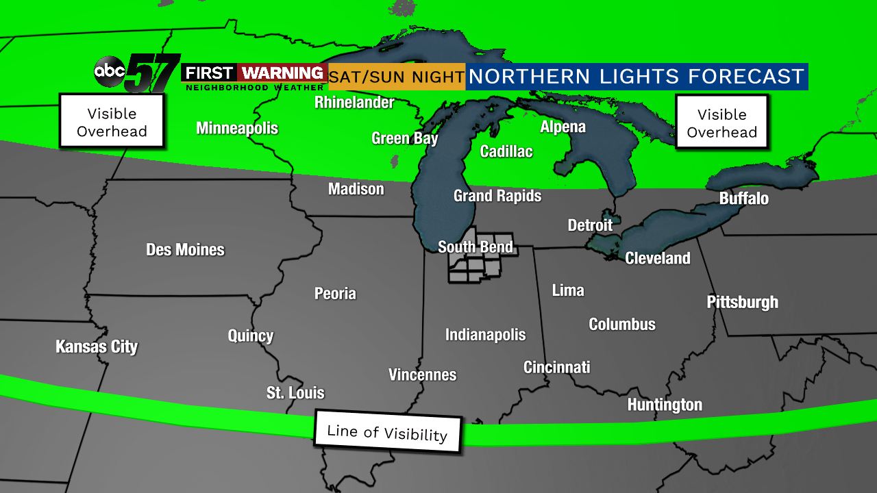
What are the chances the skies will be clear enough for this this weekend?  |
|
|
|
Post by guyatacomputer - NE St. Peters on Aug 29, 2019 17:34:38 GMT -6
Chris hit the forecast bang on this morning. He said this evening's storms would largely miss STL but may cause problems in central MO and would curve towards SW Missouri
|
|
|
|
Post by jeffcobeeman on Aug 29, 2019 17:40:57 GMT -6
What are the chances the skies will be clear enough for this this weekend?  When would be the best viewing? |
|
|
|
Post by Jeffmw on Aug 29, 2019 18:48:54 GMT -6
You know Summer is coming to an end when it gets dark before 8pm again.
|
|