|
|
Post by perryville on Jan 31, 2019 11:58:41 GMT -6
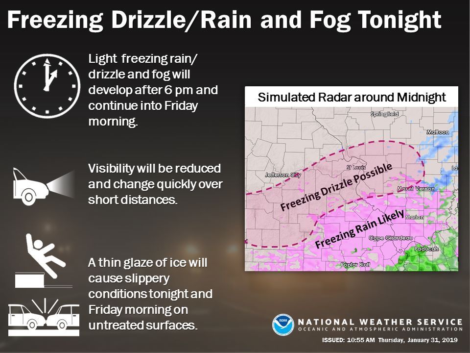
US National Weather Service Saint Louis Missouri 39 mins · Warmer air is surging north from the Gulf of Mexico and will collide with the arctic air mass entrenched over the lower Missouri and middle Mississippi River Valleys to produce light freezing rain, freezing drizzle and fog tonight across much of southeast and east central Missouri, as well as southern Illinois. Forecast confidence continues to increase on the likelihood of a light ice accumulation or glaze impacting these areas which will cause hazardous driving conditions on untreated surfaces. Fog will also reduce visibility overnight. The light precipitation looks to develop this evening and continue into Friday morning. Image may contain: text 6464 29 Comments208 Shares Hate when people ask this but what time frame we looking at? Calling a basketball game in Bollinger County. Wondering if I would be better to take the straight roads coming home or through the hills. Should be around 9 pm. |
|
|
|
Post by perryville on Jan 31, 2019 12:01:32 GMT -6
Should be some headline changes forthcoming from NWS in relation to icing potential tonight, along and S of I-44 corridor Familiar with Bollinger County? I can run 91 back to 25 to I-55 or take 51 all the way home (shorter but through the hills.) May take my Yukon in case I slide off and I can get back on the road 🤔 |
|
|
|
Post by beaker - Dardenne Prairie, MO on Jan 31, 2019 12:03:56 GMT -6
US National Weather Service Saint Louis Missouri 39 mins · Warmer air is surging north from the Gulf of Mexico and will collide with the arctic air mass entrenched over the lower Missouri and middle Mississippi River Valleys to produce light freezing rain, freezing drizzle and fog tonight across much of southeast and east central Missouri, as well as southern Illinois. Forecast confidence continues to increase on the likelihood of a light ice accumulation or glaze impacting these areas which will cause hazardous driving conditions on untreated surfaces. Fog will also reduce visibility overnight. The light precipitation looks to develop this evening and continue into Friday morning. Image may contain: text 6464 29 Comments208 Shares Hate when people ask this but what time frame we looking at? Calling a basketball game in Bollinger County. Wondering if I would be better to take the straight roads coming home or through the hills. Should be around 9 pm. I think you should advocate for an east west highway thats straight through there. Those country zig zag hilly roads are terrible! Itll never happen though. |
|
|
|
Post by beaker - Dardenne Prairie, MO on Jan 31, 2019 12:06:28 GMT -6
Should be some headline changes forthcoming from NWS in relation to icing potential tonight, along and S of I-44 corridor Familiar with Bollinger County? I can run 91 back to 25 to I-55 or take 51 all the way home (shorter but through the hills.) May take my Yukon in case I slide off and I can get back on the road 🤔 91 to 25...coming from somebody who grew up down there. |
|
|
|
Post by beaker - Dardenne Prairie, MO on Jan 31, 2019 12:08:03 GMT -6
Actually im familiar with 25. 91 im not familiar with. Im assuming youre going to marble hill?
|
|
|
|
Post by mchafin on Jan 31, 2019 12:11:08 GMT -6
lovely. early morning hospital appointment tomorrow should make skating on 270 fun.
|
|
|
|
Post by maddogchief on Jan 31, 2019 12:12:27 GMT -6
ILX morning disco is pretty vague. They didn’t get fancy with temps this weekend, the system Sunday night, or the midweek system. In their defense though, they have a really complex forecast area going on with a substantial snowpack in the north, a mediocre pack in the middle and none in the SE. Not to mention the orientation of the ridge coming in likely bisects their forecast area. All affecting temps and p-types
|
|
|
|
Post by beaker - Dardenne Prairie, MO on Jan 31, 2019 12:12:56 GMT -6
If marble hill consider 34...i think that gets you to jackson where you can hit 55. I remember a 25 but i seem to think thats really either 72 or 34. I wld not do 51 tonight for sure.
|
|
|
|
Post by perryville on Jan 31, 2019 12:14:00 GMT -6
Actually im familiar with 25. 91 im not familiar with. Im assuming youre going to marble hill? Coming from Zalma. Worse than Marble Hill  . 91 runs from Advance to Zalma. |
|
|
|
Post by perryville on Jan 31, 2019 12:15:32 GMT -6
If marble hill consider 34...i think that gets you to jackson where you can hit 55. I remember a 25 but i seem to think thats really either 72 or 34. I wld not do 51 tonight for sure. 34 would be a good option. But have to get on 51 to get to 34. Not sure any option is great. |
|
|
|
Post by beaker - Dardenne Prairie, MO on Jan 31, 2019 12:18:06 GMT -6
Oh! Youre talking abt 91 southbound to and hitting 25. Thats further down than i thght where you wanted to go. Im looking at a map now. If you are at zalma or dongola do that. If marble hill, 34 is actually pretty good.
|
|
|
|
Post by cardsnweather on Jan 31, 2019 12:18:33 GMT -6
Last huge ice storm was definitely 2007.
OR some may say December 15, 2016.
|
|
|
|
Post by Snowstorm920 on Jan 31, 2019 12:19:48 GMT -6
12z FV3 certainly lends support to the Icon. So, pretty big run of the euro upcoming. Ya that's a big ice and snowstorm it has
Would fit the pattern pretty well
|
|
|
|
Post by Snowstorm920 on Jan 31, 2019 12:23:37 GMT -6
That FV3 run is a parade of ice and snowstorms. I counted 4 separate ones over the next 10 days
|
|
|
|
Post by perryville on Jan 31, 2019 12:25:36 GMT -6
Oh! Youre talking abt 91 southbound to and hitting 25. Thats further down than i thght where you wanted to go. Im looking at a map now. If you are at zalma or dongola do that. If marble hill, 34 is actually pretty good. Thank you! I think Modot can handle 91/25 better than 51. Takes 1 slick spot in the hills and you can be in a tree on 51. |
|
|
|
Post by addicted2wx - Villa Ridge, Mo on Jan 31, 2019 12:27:08 GMT -6
Things are looking IMO increasingly likely at this stage of the game and this far out for a pretty impactful winter-type event especially STL metro south around here ~Thursday. Surprisingly all the big guys are on board (EURO, Super-GFS, ICON) and all the under performers are the only models that don’t agree on a system to affect us (GFS, GEM). I know it’s early at this stage but it’s hard to discount the early trends. Especially with a northern shift present this year...atleast for me..I feel we have a good chance at another impactful event next week especially with cold air returning.
|
|
|
|
Post by perryville on Jan 31, 2019 12:32:45 GMT -6
Talked to shop that replaced my encoder on my 4x4 two years ago. He gave some good advice that the 4-wheel drive can actually freeze up or get hung up, so use it even if you don’t need it every once in a while. Especially in this cold weather.
|
|
|
|
Post by beaker - Dardenne Prairie, MO on Jan 31, 2019 12:34:20 GMT -6
Oh! Youre talking abt 91 southbound to and hitting 25. Thats further down than i thght where you wanted to go. Im looking at a map now. If you are at zalma or dongola do that. If marble hill, 34 is actually pretty good. Thank you! I think Modot can handle 91/25 better than 51. Takes 1 slick spot in the hills and you can be in a tree on 51. The numbers are confusing because the highways turn. But 25 gives you several options to hit 55....via 74 by south cape, route k at gordonville going toward cape, or 25 through jackson. All are pretty straight. |
|
|
|
Post by perryville on Jan 31, 2019 12:38:19 GMT -6
Paducah NWS is saying midnight start time. I trust them about as much as I trust my 10 year old with winter weather. Anyone have an earlier start time down this way?
|
|
|
|
Post by perryville on Jan 31, 2019 12:40:47 GMT -6
Thank you! I think Modot can handle 91/25 better than 51. Takes 1 slick spot in the hills and you can be in a tree on 51. The numbers are confusing because the highways turn. But 25 gives you several options to hit 55....via 74 by south cape, route k at gordonville going toward cape, or 25 through jackson. All are pretty straight. Glad someone else knows about the land of the lost . Beautiful country but not during winter weather. |
|
|
|
Post by cardsnweather on Jan 31, 2019 12:41:07 GMT -6
Euro has an overrunning rain event from Tuesday morning into Wednesday at first look.
Ramps it up Thursday morning as low passes.
|
|
|
|
Post by guyatacomputer - NE St. Peters on Jan 31, 2019 12:42:40 GMT -6
That FV3 run is a parade of ice and snowstorms. I counted 4 separate ones over the next 10 days What year was it in the late 80s people went ice skating in the their yards? |
|
|
|
Post by STGOutdoors on Jan 31, 2019 12:44:00 GMT -6
Good grief the FV3 goes nuts with ice and snow for the mid next week system. Again, fits the pattern just like the ICON. Sometimes you look at it and just say, "Yep, that makes sense."
|
|
|
|
Post by cardsnweather on Jan 31, 2019 12:45:15 GMT -6
Right now, fv3 and icon hold just as much weight as the Euro does, IMO.
|
|
|
|
Post by STGOutdoors on Jan 31, 2019 12:46:54 GMT -6
Euro has an overrunning rain event from Tuesday morning into Wednesday at first look. Ramps it up Thursday morning as low passes. Overruning as in shallow cold air is in place...so frz rain? |
|
|
|
Post by cardsnweather on Jan 31, 2019 12:50:03 GMT -6
Euro has an overrunning rain event from Tuesday morning into Wednesday at first look. Ramps it up Thursday morning as low passes. Overruning as in shallow cold air is in place...so frz rain? No. Temps way too warm. |
|
|
|
Post by perryville on Jan 31, 2019 12:50:21 GMT -6
That FV3 run is a parade of ice and snowstorms. I counted 4 separate ones over the next 10 days What year was it in the late 80s people went ice skating in the their yards? I want to say 89 for down here. We had freezing rain on top of sleet/snow. You couldn’t walk and driving was impossible on the back roads. Seems like it hit right after the new year. When we would get close to going back to school, more freezing rain would hit. |
|
|
|
Post by cardsnweather on Jan 31, 2019 12:51:20 GMT -6
Euro has lots of moisture coming through, especially south. Nothing frozen though.
|
|
|
|
Post by addicted2wx - Villa Ridge, Mo on Jan 31, 2019 12:53:07 GMT -6
Right now, fv3 and icon hold just as much weight as the Euro does, IMO. I’d give them a close second. In my opinion they have all done very well out especially in the long range. And the underdog ICON..well I don’t think people give that model enough credit. It’s in in my top three list for long range trends right now with the EURO and the FV3. |
|
|
|
Post by cardsnweather on Jan 31, 2019 12:54:14 GMT -6
 Sorry if this has been posted already. |
|


 . 91 runs from Advance to Zalma.


