|
|
Post by BRTNWXMAN on Jan 20, 2019 10:15:49 GMT -6
The models show the good band over Eastern Iowa essentially vanishing the next couple of hours and reforming quite a bit weaker SW of this bands trajectory RAP develops a nice band over the SW counties but satellite imagery looks like it's aimed right down the river to me. |
|
|
|
Post by amstilost on Jan 20, 2019 10:40:33 GMT -6
On visible satellite, the 3-4 hours since sun has been up, you can see what looks like a 'river channel' coming from the NW to the SE through Iowa. What looks fascinating to me is the flow is moving faster in the middle of the 'channel' vs either side. You can see 'agitated' clouds (probably not cumulus) on either side of the channel also. It looks like the flow around the western HP will direct more of a northerly component to this this afternoon. I just wonder if this will be the mechanism to enchance the redevelopement to the SW of main band of snow that the HRRR is suggesting. Any thoughts on this? and BTW, these new weather satellites show so much stuff. |
|
|
|
Post by amstilost on Jan 20, 2019 10:56:49 GMT -6
It will be interesting to see if reality unfolds like the 14z and 15z HRRR are showing. If this does in fact occur would that be classifies as a transfer of energy? or a jet streak? or maybe just a bone thrown to some of us that get excited over a 1/2-1" dusting.  |
|
|
|
Post by BRTNWXMAN on Jan 20, 2019 11:25:36 GMT -6
On visible satellite, the 3-4 hours since sun has been up, you can see what looks like a 'river channel' coming from the NW to the SE through Iowa. What looks fascinating to me is the flow is moving faster in the middle of the 'channel' vs either side. You can see 'agitated' clouds (probably not cumulus) on either side of the channel also. It looks like the flow around the western HP will direct more of a northerly component to this this afternoon. I just wonder if this will be the mechanism to enchance the redevelopement to the SW of main band of snow that the HRRR is suggesting. Any thoughts on this? and BTW, these new weather satellites show so much stuff. The RAP output/sim radar was showing the band re-developing further SW but the 850/700 charts had the best moisture and convergence(Fgen) right down the river through the event. So I'm not so sure it will actually develop that way...but these narrow bands are tricky to pinpoint. |
|
|
|
Post by BRTNWXMAN on Jan 20, 2019 11:27:53 GMT -6
Radar out of DSM definitely shows two distinct bands though...we'll see.
|
|
|
|
Post by amstilost on Jan 20, 2019 11:37:42 GMT -6
Radar out of DSM definitely shows two distinct bands though...we'll see. I was just going to post on the conus radar it showed two different snow bands. Beat me to it. I still have pretty bright but milky sunshine in de soto. Temp says 48*. Obviously something wrong there. |
|
|
|
Post by bororug on Jan 20, 2019 11:55:37 GMT -6
Radar out of DSM definitely shows two distinct bands though...we'll see. I was just going to post on the conus radar it showed two different snow bands. Beat me to it. I still have pretty bright but milky sunshine in de soto. Temp says 48*. Obviously something wrong there. I like where we’re at for this little batch of snow that’s coming, amstilost. |
|
|
|
Post by Worldserieschampions (Chicago) on Jan 20, 2019 11:59:26 GMT -6
Looks like we are in the fast northwest flow for the next 7-10 days before things relax back and allow for the southern stream to reemerge.
Should have ample light snow chances before February brings some significant winter storm potential.
|
|
|
|
Post by jmg378s on Jan 20, 2019 12:02:32 GMT -6
Looks like the band through MO is largely driven by some 925mb-700mb frontogenesis/convergence. You can see the thermal gradients tightening a bit with time in the mesoanalysis.
|
|
|
|
Post by cardsnweather on Jan 20, 2019 12:05:06 GMT -6
Anyone have anything falling yet?
|
|
padlur
Junior Forecaster
 Ballwin(by the golf course)
Posts: 304 
|
Post by padlur on Jan 20, 2019 12:09:42 GMT -6
Bowling Green to Hannibal looks healthy on radar... anything in reality?
|
|
|
|
Post by showtime - Marissa on Jan 20, 2019 12:11:42 GMT -6
NWS seems to like the right down the river forecast also.... an inch or less for most of us
|
|
WeatherOrNot
Weather Weenie
 Hull, IL (NW corner Pike Co., IL)
Posts: 36
|
Post by WeatherOrNot on Jan 20, 2019 12:15:34 GMT -6
It's been snowing for 30 minutes here. Visibility 1.5 miles.
|
|
|
|
Post by unclesam6 on Jan 20, 2019 12:21:40 GMT -6
nothing in Columbia... radar would suggest we're at least getting a LIGHT snow burst. Dry air winning out.
|
|
|
|
Post by unclesam6 on Jan 20, 2019 12:23:56 GMT -6
sucks that MZZU is still down from last weekend's storm. Would be really telling at the moment.
|
|
|
|
Post by BRTNWXMAN on Jan 20, 2019 12:40:38 GMT -6
Yeah dry air is an issue for sure...current Td is 6*F with a temp of 15*. It will take a good burst to break through I would say...coatings might be spotty. This would be healthier if it were at night with less diurnal heating/drying. That's one of the reasons clipper snows seem to favor the nighttime, around here especially.
|
|
|
|
Post by perryville on Jan 20, 2019 12:41:21 GMT -6
This was Highway AA in Perry County earlier. You can see the mailbox on the left. Numerous county roads are closed. Photo credit to Carl Manche  |
|
|
|
Post by Steven Penrod- HLEW on Jan 20, 2019 12:42:09 GMT -6
...Light to Moderate Snow this Afternoon into this Evening...
A band of light to moderate snow currently over portions of
southeast Iowa, west-central Illinois and northeast Missouri will
continue to track southeast this afternoon. Light to moderate snow
will overspread areas generally along and west of the Mississippi
River with a quick hit of minor accumulations of around one-half
an inch over the next 6 hours. Locally up to an inch of snow is
possible where moderate snow occurs. Snow will result in periods
of limited visibility and slick spots on area roadways through
this evening. The powdery nature of the snowfall will also allow
for accumulated snow to become lofted behind vehicles and
refreeze on area roadways tonight. This could cause additional
disruption to travelers for those not only driving today, but also
after snow comes to an end late this evening.
|
|
|
|
Post by BRTNWXMAN on Jan 20, 2019 12:51:18 GMT -6
This was Highway AA in Perry County earlier. You can see the mailbox on the left. Numerous county roads are closed. Photo credit to Carl Manche Yeah...that's the kind of drifting a blizzard creates. |
|
|
|
Post by ajd446 on Jan 20, 2019 12:53:56 GMT -6
Flurries in st.peters
|
|
|
|
Post by Chris Higgins on Jan 20, 2019 12:54:41 GMT -6
Radar donut hole is contracting to the north....saturation seems to be underway in a band just west of the river. If the band stays stationary in NW/SE orientation...may be a few 1"+ totals.
|
|
|
|
Post by Chris Higgins on Jan 20, 2019 12:59:34 GMT -6
This was Highway AA in Perry County earlier. You can see the mailbox on the left. Numerous county roads are closed. Photo credit to Carl Manche Yeah...that's the kind of drifting a blizzard creates. No doubt yesterdays system qualified as a blizzard IMO. I just wish I had a better handle on the evolution of the snow and could have better served the public with a forecast. I guess I can take comfort in the idea that we hit the wording hard...and did have most of SE viewing in 2-4 already... with "blizzard like" conditions. For S/E viewers...I think they were well served by my forecast. But for the have nots who missed it... it was a bad bust. One of the storms when the chacter of the storm "blizzard-like" was nailed... just positioning details off. |
|
|
|
Post by unclesam6 on Jan 20, 2019 13:09:08 GMT -6
column saturating. skies darkening. stray flakes beginning to fall.
|
|
|
|
Post by BRTNWXMAN on Jan 20, 2019 13:11:33 GMT -6
Flurries breaking through here.
|
|
|
|
Post by cardsnweather on Jan 20, 2019 13:17:31 GMT -6
 Lol |
|
|
|
Post by unclesam6 on Jan 20, 2019 13:21:07 GMT -6
back to nothing.
|
|
padlur
Junior Forecaster
Ballwin(by the golf course)
Posts: 304
|
Post by padlur on Jan 20, 2019 13:21:38 GMT -6
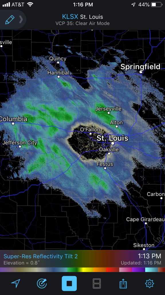
Definition of snow donut...
I see a new shirt there
|
|
|
|
Post by pbc12871 on Jan 20, 2019 13:22:53 GMT -6
Looks like a swirling black hole. How apropos.
|
|
|
|
Post by STGOutdoors on Jan 20, 2019 13:25:51 GMT -6
This was Highway AA in Perry County earlier. You can see the mailbox on the left. Numerous county roads are closed. Photo credit to Carl Manche Thanks for posting. This picture really captures what happened here yesterday. This is one I'll never forget. I-55 is still 50% covered down here. Took a drive around and saw lots of 2-3 foot drifts, even some approaching 4. What an awesome experience. |
|
|
|
Post by unclesam6 on Jan 20, 2019 13:26:12 GMT -6
POOF.
SN-
|
|


